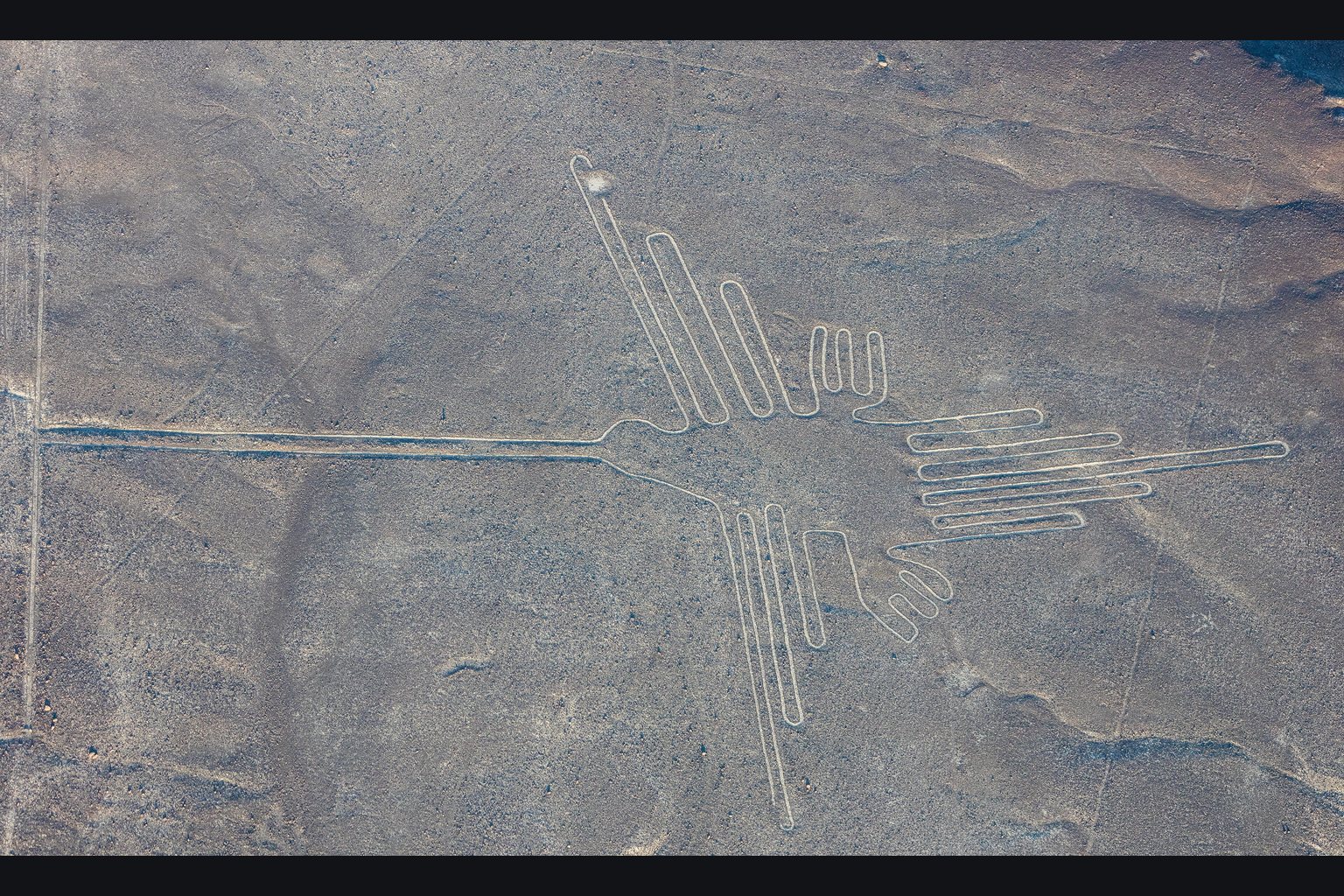
Over a thousand lines, some of them running more than ten kilometres, cut into a plateau that gets about twenty minutes of rain a year. Animal figures up to 370 metres (1,214 ft) across. A society with no writing, no wheel and very little water spent something like a thousand years making them, and then stopped.
Stand on the pampa and you are looking at a pale scratch in dark gravel, stretching to the horizon. Climb into a light aircraft and a hummingbird assembles itself beneath you, perfectly proportioned, two hundred feet from beak to tail.
That gap between what you see on the ground and what you see from the air is the whole argument about the Nazca Lines. It has been read two ways for sixty years, and both readings are still in print.
What Are the Nazca Lines?
The Nazca Lines are geoglyphs cut into the desert plateau between the Nazca and Ingenio valleys in southern Peru, made principally by the Nazca culture between roughly 500 BC and AD 500, with some earlier Paracas examples.
They include:
- Over 1,000 straight lines, some running more than 10 km (6.2 miles)
- Around 300 geometric figures — trapezoids, triangles, spirals, zigzags
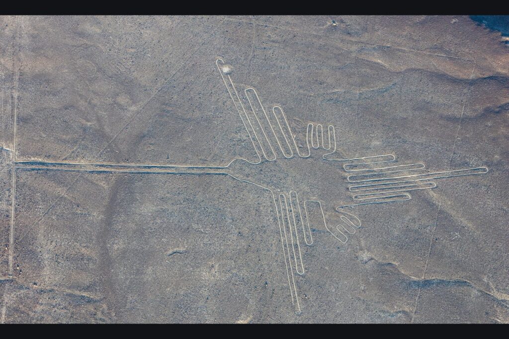
- Dozens of biomorphs — hummingbird, spider, monkey, condor, whale, tree, hands
- Figures up to roughly 370 metres (1,214 ft) across
UNESCO inscribed them as a World Heritage Site in 1994.
How They Were Made
The technique itself is not disputed by anyone.
The Nazca desert floor is covered with a layer of pebbles coated in iron oxide, oxidised to a dark reddish-brown. Immediately beneath is pale yellow-grey clay and sand.
To make a line, you remove the dark pebbles and expose the light ground underneath. No cutting, no carving, no excavation — just clearing a strip of surface stones and piling them at the edges, which creates a slight raised border that increases the contrast.
Depth is typically 10 to 30 cm (4 to 12 in). A modern team reproduced a figure the size of the well-known ones in a matter of days, using wooden stakes and cord. Precision over long distances is achievable by sighting along stakes, a technique any surveyor would recognise. Wooden posts have been found at line terminals, and radiocarbon dates from them fall in the Nazca period.
Why They Survived
The remarkable thing is not the making. It is the persistence.
The plateau is one of the driest places on earth, receiving roughly 20 minutes of rain a year. It is nearly windless at ground level, partly because the dark stones absorb heat and create a thin cushion of warm air that buffers the surface. There is no vegetation and almost no erosion.
Under those conditions a cleared strip stays cleared for millennia. Almost anywhere else on earth, these would have gone within a century.
The Case for Something From Above
Erich von Däniken put this in Chariots of the Gods? in 1968, and it is worth stating the way he and his readers state it, because the flattened version does it no favours.
The starting point is an observation anyone makes on their first flight over the pampa. The long trapezoids look like cleared strips. They are flat, they are enormous, they narrow along their length, and they sit in a landscape where nothing else is flat and cleared. The resemblance is not manufactured by believers; it is the first thing most people think.
From there the argument runs:
- The figures are composed for an aerial viewer. A 370-metre hummingbird is not a picture at ground level. Its proportions only resolve from height. Why compose for a viewpoint you cannot reach?
- The labour is disproportionate to any local use. Centuries of sustained work by a society under water stress, for markings most of its members could never see whole.
- The precision is hard to explain at that scale. Straight lines holding their bearing across kilometres of uneven ground, laid out by people with no instruments we have found.
- They stopped. The practice ends with the Nazca culture. If the lines served a continuing local purpose, why does nobody continue it?
Von Däniken’s own position moved over the years — from a landing site, to the idea that people built crude copies of something they had seen in the hope of calling the visitors back, to a later version about a craft in orbit surveying for raw materials. The variation is often used against him. It also means the claim he is best known for is not the only one he made.
The Case Against It
The objections are mostly physical rather than philosophical, and they are specific.
The ground will not take an aircraft. The surface is loose pebbles over fine sand and clay. Anything heavy landing on it would sink and leave a scar — and this is a landscape that holds a footprint for centuries. The “runways” show no such damage.
The trapezoids are the wrong shape for runways. They vary enormously in width, they taper along their length, and some of them run up and over hills, following the terrain instead of demanding flat ground.
They are not only visible from the air. This is the load-bearing premise of the aerial-viewer argument, and it does not hold in the strong form. Many geoglyphs are clearly visible from the foothills that bound the plateau, and figures were positioned where people on high ground could take them in.
The 2024 survey pushed that further. A study led by Masato Sakai of Yamagata University, working with IBM on AI-assisted analysis of aerial imagery, reported 303 newly identified figurative geoglyphs in six months — against roughly 430 found in the previous century. Many of the new ones are small, faint, and sited beside walking routes, at a scale meant to be seen from a few metres away by someone on foot.
And the making is not mysterious. Stakes, cord, a technique demonstrable in days.
What the Archaeology Points To
None of the mainstream readings is proven either. They are interpretations, and they compete.
The astronomical calendar. Paul Kosok called the site “the largest astronomy book in the world” in the 1940s, and Maria Reiche spent five decades developing and defending the idea that the lines marked solstices, risings and settings. In 1968 the astronomer Gerald Hawkins ran the alignments against a computer model of the ancient sky and found the number matching significant events was no better than chance — with a thousand lines radiating in all directions, some will point at something. Later studies repeated the result. Reiche’s reading is not currently supported by the alignment data, though her work is why the site still exists to argue about.
Water and fertility. The region is desperately arid and its civilisation depended on subterranean aqueducts, the puquios, some still running. Researchers including Johan Reinhard noted that many lines point toward water sources, that trapezoids often open toward valleys and watercourses, and that the animal figures are overwhelmingly water- or fertility-associated in Andean symbolism: the spider, the hummingbird, the whale, the monkey.
Ritual pathways. Lines show wear consistent with foot traffic, and broken pottery offerings concentrate at line ends and along them. Most biomorphs are drawn as a single continuous line with an entry and an exit.
Ceque-like social markers. In Inca Cusco, lines called ceques radiated from the centre and organised land, water rights and ritual duty between kin groups. Something similar may have operated at Nazca.
These are compatible with each other. A line can be a path, a water marker and a boundary at once.
What Nobody Has Explained
Whichever reading you find stronger, the following are open.
Why so many? Over a thousand lines, maintained across centuries — a staggering investment by a society with little surplus.
Why these animals? The biomorphs include a monkey and a whale, neither native to the plateau. One belongs to the Amazon over the mountains, the other to the ocean. That is a symbolic geography reaching far beyond the local landscape, and nobody knows how it was assembled.
Why did it stop? Geoglyph-making declines with the Nazca culture around AD 500, in a period of severe drought, possibly worsened by the clearing of the huarango trees that held the soil.
How many are there? Still unknown. The 2024 count roughly doubled one category of figure in six months. The honest answer is that we do not yet know the size of the thing we are arguing about.
The same shape of argument runs through other sites where the scale outruns the obvious explanation — Göbekli Tepe, raised before agriculture; the Great Pyramid, whose workers’ village has been excavated; the Baghdad jar, a sealed cylinder of a type found elsewhere holding scrolls. In each case there is a documented human account and a more dramatic one, and readers weigh them differently.
Frequently Asked Questions
What are the Nazca Lines?
Geoglyphs cut into the desert plateau of southern Peru, made mainly by the Nazca culture between roughly 500 BC and AD 500. They include over 1,000 straight lines, around 300 geometric figures and dozens of animal shapes, some up to 370 metres (1,214 ft) across.
How were the Nazca Lines made?
By removing the dark, iron-oxide-coated pebbles covering the desert floor to expose the pale clay and sand beneath, typically to a depth of 10 to 30 cm (4 to 12 in). The cleared stones were piled at the edges, increasing contrast.
Can the Nazca Lines only be seen from the air?
Not entirely. Many are visible from the foothills that surround the plateau, and the smaller figures identified in 2024 sit beside walking routes at a scale meant to be seen from a few metres away. The largest figures are still best taken in from height.
Were the Nazca Lines landing strips?
That is the best-known version of Erich von Däniken’s 1968 argument, and it rests on the resemblance between the long trapezoids and cleared runways. Against it: the surface is loose pebbles over sand and cannot bear an aircraft, the trapezoids taper and vary in width, and some run up and over hills.
Are the Nazca Lines an astronomical calendar?
Maria Reiche argued they were. Gerald Hawkins tested the alignments against the ancient sky in 1968 and found matches no better than chance, a result later studies repeated. The idea remains influential but is not supported by the alignment data.
Why have the Nazca Lines survived so long?
The plateau receives roughly 20 minutes of rain a year, is nearly windless at ground level, has no vegetation and almost no erosion. A cleared strip stays visible for thousands of years.
How many Nazca Lines are there?
More than anyone thought. A 2024 study led by Masato Sakai, using AI-assisted analysis of aerial imagery, reported 303 newly identified figurative geoglyphs in six months, against about 430 found in the previous century.
Why did the Nazca stop making them?
The practice declines with the Nazca culture itself around AD 500, during a period of severe drought that may have been worsened by the clearing of huarango trees that stabilised the soil.
What Would Settle It
Each reading makes a demand on the evidence, and the demands are testable.
For the visitor reading to hold, something on that plateau has to be inconsistent with what the Nazca could do — a material, a tolerance, a structure that stakes and cord do not account for. Sixty years of survey have not produced it, but the survey is demonstrably incomplete: one AI-assisted season in 2024 found 303 figures nobody knew were there.
For the pathway reading to hold, the figures should keep turning up where people walked, and should keep being shaped for walking rather than for looking. So far that is what the new finds show.
And then there is the detail that keeps both sides interested.
The hummingbird, the monkey, the spider are drawn as one continuous line that never crosses itself. You can enter at one end, walk the entire figure without stepping over your own path, and come out the other side.
You do not need that to make a picture. Any number of strokes will do, and from a plane nobody would see the difference. You need it if the figure is something you walk — which is why archaeologists point at it.
Or, if you prefer the other reading: you need it if the figure is a signal, and whoever drew it wanted the line unbroken.
The desert has kept both possibilities for fifteen hundred years. It is not in a hurry, and neither are you.
Continue Reading
- Puma Punku: The H-Blocks and the Half-Finished Stones — The blocks look machined. But the giant stones are the soft ones, the precise ones are the hard ones, and the site is…
- The Sumerian King List: 241,200 Years Before the Flood — Eight kings, 241,200 years, then a flood. Almost every retelling adds the numbers up — and what that shape means is the…
- The Viking Sunstone: How It Works, and What Has Been Found — The physics is settled: a calcite crystal really can locate the sun through cloud. Everything else is argued — the one…