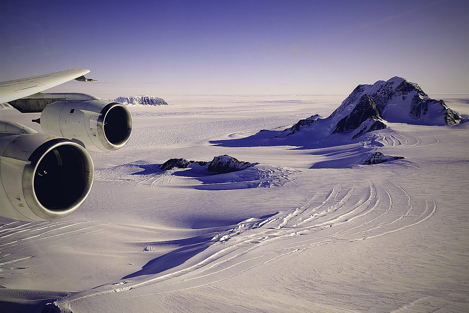
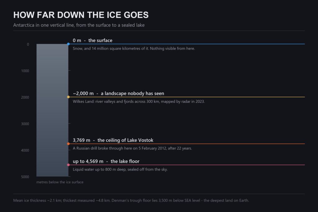
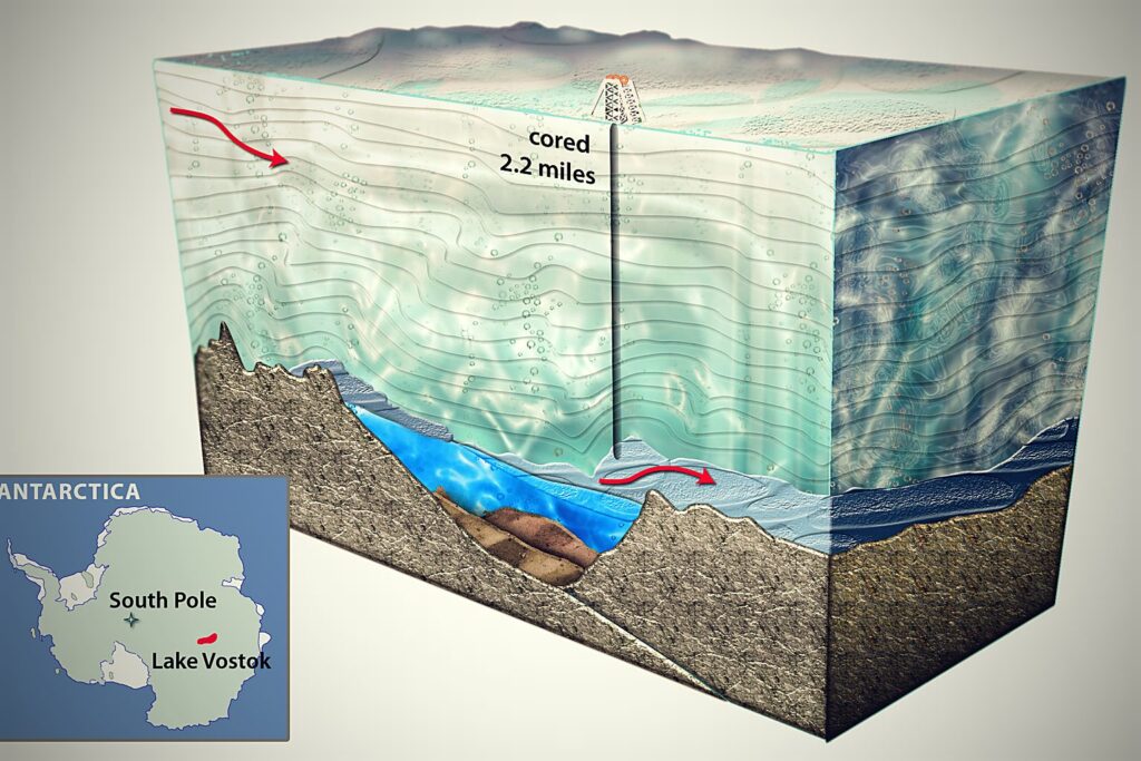
On 5 February 2012, after twenty-two years of drilling, a Russian team at Vostok Station broke through 3,769 metres (12,365 feet) of ice and touched liquid water that had been sealed off from the sky since long before anyone was there to look at it.
That is a real sentence about a real hole. And it is the reason Antarctica collects stories the way it does: what is under Antarctica’s ice is, for the overwhelming majority of the continent, genuinely unknown. Nobody has seen the ground. It has been mapped by bouncing radio waves through two to four kilometres of ice and reading what comes back.
A place that large, that blank, and that hard to reach will always attract claims. Some of them are worth taking seriously for a few minutes. What the radar found is stranger than most of them.
What Is Under Antarctica’s Ice?
Underneath the ice sheet are a buried mountain range the size of the Alps that no human eye has ever seen, at least 675 lakes of liquid water, the deepest canyon on any land surface on Earth, a river-carved landscape roughly 300 kilometres (190 miles) across that has sat undisturbed since before the ice arrived, and the fossilised remains of forests.
There are no confirmed pyramids, no confirmed bases and no confirmed openings into a hollow interior. But the honest version of that sentence has to include how little of the bedrock has actually been examined, and the answer is: almost none of it directly.
The Pyramid
A photograph circulates showing a near-perfect four-sided peak standing alone in the ice, usually captioned as an Antarctic pyramid. The mountain is real and the photograph is not doctored. It stands in the Ellsworth Mountains.
The case that it is built rests on the regularity: four faces of similar pitch meeting at a single apex, isolated on a plain, with no obvious reason for a natural hill to be that symmetrical.
The case that it is not is that geology has a name for the shape and a mechanism that produces it. A peak like that is a glacial horn, carved when three or more glaciers grind away at the same summit from different sides. The Matterhorn is the same shape by the same process, and nobody proposes it was quarried. Peaks that break through the ice sheet like this are called nunataks, and Antarctica has thousands of them.
What makes the horn explanation hard to argue with here is that it predicts the isolation rather than being embarrassed by it. Nunataks stand alone because the ice has removed everything around them. If you are looking for a shape that an ice sheet is unusually good at producing, a pyramid is near the top of the list.
The deeper problem is the one the Face on Mars ran into: a remote-sensed shape, on its own, is weak evidence in both directions. It cannot establish that something was built, and treating “natural” as the default cannot detect it if it was.
Operation Highjump and the Fleet That Went Home Early
In late 1946 the US Navy sent Task Force 68 to Antarctica: roughly 4,700 men, thirteen ships and dozens of aircraft, under Rear Admiral Richard Byrd. It was the largest expedition the continent had ever seen. It was scheduled to run through the season and it packed up early.
Four men died. Three of them went down in a PBM Mariner that crashed in a whiteout.
The case that something happened is built on that early departure, on the size of the force, and above all on an interview Byrd gave to the Chilean newspaper El Mercurio on 5 March 1947, in which he warned that the United States would need to take defensive measures against hostile craft coming from the polar regions at extraordinary speed.
The case that it did not starts with the Spanish. The word in the El Mercurio piece is aviones — aircraft. Byrd, in March 1947, was making an entirely conventional Cold War argument: the shortest route for a Soviet bomber to reach North America runs over the pole, and the polar regions were therefore about to matter militarily. He was right about that, and it is why the DEW Line got built. The rendering of aviones as “flying objects” came later, in retellings, and it carries a meaning the source does not.
The second thread is the Missing Diary of Admiral Richard E. Byrd, published in 1990, which describes flying into a warm interior world. Textual analysis has identified multiple independent markers of forgery in it, and it appeared decades after Byrd’s death in 1957.
The third is where the Nazi version came from. It was pushed hardest by a German-Canadian publisher writing as “Christof Friedrich” — Ernst Zündel, better known for Holocaust denial — who wove Highjump together with a story of a surviving Reich. That does not make every claim in it false by association, but it is relevant to how the story was assembled and by whom.
What remains genuinely true: the expedition was very large, it did end ahead of schedule, and the official reason was weather, ice conditions and the closing season. Whether that is sufficient is the argument.
New Swabia
This part is not folklore. In 1938–39 Germany sent the Schwabenland south under Alfred Ritscher, photographed a large area of what is now Queen Maud Land from the air, dropped marker darts, and claimed the territory as Neuschwabenland. The expedition happened, the maps exist, and the ambition was real enough.
What is not attested is Base 211, the underground installation the story requires. There is no construction record, no logistics trail, and no material found. An Antarctic base is not a small thing to hide: it needs fuel, food, and repeated resupply across the worst sea passage on the planet.
The fair summary is that Germany’s Antarctic interest was real and documented, and everything built on top of it after 1945 is a separate claim that has not produced evidence.
The Hollow Earth
The idea deserves better than the eye-roll it usually gets, because of who proposed it.
In 1692 Edmond Halley — Astronomer Royal, the man the comet is named after — published a paper proposing that the Earth consists of concentric shells separated by atmosphere. He was not being whimsical. He was trying to explain why compass readings drift over time, and a set of nested shells rotating at slightly different rates would produce exactly that. It was a serious hypothesis answering a real measurement.
In 1818 John Cleves Symmes Jr added openings at the poles and campaigned for an expedition to find them. The polar openings are where Antarctica enters the story, and where the forged Byrd diary was later made to fit.
What settles it is not aesthetic but physical: seismic waves. Earthquakes send P-waves and S-waves through the planet, they arrive at monitoring stations worldwide at times that depend on what they passed through, and those arrival times map a dense iron core. S-waves do not travel through liquid, and their shadow is how the liquid outer core was found in the first place. Hollow shells would produce a completely different pattern, and they do not.
Halley’s reasoning was sound for 1692. The instruments arrived later and answered him.
What the Radar Actually Found
Here is where the subject stops being about claims, because the verified inventory is the part that should be famous.
A buried mountain range. The Gamburtsev Subglacial Mountains run roughly 1,200 kilometres (750 miles) across East Antarctica, Alpine in scale and shape, with peaks and valleys. They were detected by a Soviet expedition in 1958 and surveyed in detail during the International Polar Year in 2008–09. No one has ever seen them. They sit under kilometres of ice, and the survey found valleys in them cut by water.
At least 675 lakes. Liquid water, under the ice, kept from freezing by pressure and the planet’s own heat. About a fifth of them are “active” — they fill and drain, which means water is moving between them through channels.
Lake Vostok. The largest, about the size of Lake Ontario, under roughly 4 kilometres of ice, with a water column up to 800 metres (2,600 feet) deep. It is the one the 2012 borehole reached.
The deepest land on Earth. Under Denman Glacier there is a trough whose floor lies 3,500 metres (11,500 feet) below sea level — deeper than any other land surface on the planet, filled with ice rather than water. It was mapped for BedMachine Antarctica and announced in 2019.
A landscape nobody has seen. In October 2023, a team led by Stewart Jamieson reported in Nature Communications a river-carved landscape under Wilkes Land: highland blocks separated by fjords, roughly 300 kilometres across, cut by rivers before the ice arrived and then preserved rather than ground away, because the ice above it has stayed frozen to the bed instead of sliding. They estimate it has been sitting there untouched for something like 14 to 34 million years.
That last one is worth reading twice. It is not a discovery of ruins. It is the discovery of an entire intact countryside — valleys, ridges, drainage — that has been under a lid for longer than there have been people, and which nobody has laid eyes on.
The Forests
In January 1912, on the return march from the South Pole, Scott’s party hauled about 16 kilograms (35 pounds) of rock samples with them. They were dying and they kept the rocks. The fossils in them were Glossopteris — leaves of a seed fern — and they were found beside the bodies.
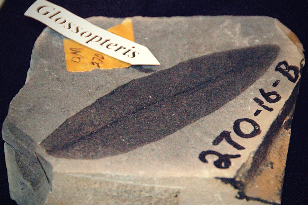
Those leaves mattered. The same plant turns up in India, South Africa, Australia and South America, and that distribution became part of the case for continental drift at a time when the idea was treated as nonsense.
Antarctica has since produced more. Cryolophosaurus ellioti, a crested predator, was excavated from the Hanson Formation and named in 1993 — the first meat-eating dinosaur described from the continent. Fossil forests have been found standing in growth position.
And in 2017 a drilling campaign in the Amundsen Sea, near the Pine Island and Thwaites glaciers, pulled up a sediment core with a section that looked wrong — the wrong colour. A CT scan showed a dense mat of fossil roots, preserved well enough to make out individual cells, along with pollen and spores from dozens of plants. Johann Klages and colleagues published it in Nature in 2020 and read it as a temperate swampy rainforest that grew within a few hundred miles of the South Pole, in a place that has four months of darkness a year. They dated the material to roughly 90 million years ago.
Whatever timescale you hold, the physical fact is not in dispute: there are forest soils under the Antarctic ice sheet, with the roots still in them.
What Genesis Has to Do With It
This site reads these things from a creationist position, and this is a case where the position changes the question rather than the evidence.
Nobody disputes the roots, the leaves or the pollen. What is disputed is the clock. The conventional reading, which is what Klages and colleagues published, places that rainforest around 90 million years ago and Scott’s Glossopteris at roughly 250 million, with the ice sheet arriving tens of millions of years later and the Wilkes Land landscape frozen in place since.
The catastrophist reading, which creationist geologists such as Michael Oard have argued in detail, compresses all of it: a single global Flood that buried vegetation fast and in quantity, followed by warm oceans and cold continents driving one sharp ice age lasting centuries rather than a sequence of them lasting millions of years. The same question about how quickly a climate can turn sits underneath the Younger Dryas argument, where the disputed cold snap is measured in decades. On that reading the forest soils, the fossil beds and the ice above them are close together in time, not separated by eras.
The two readings are not distinguished by the fossils. They are distinguished by how the dating methods are assessed, which is a separate argument with its own literature and its own unresolved points. What both sides agree on is the thing most people find hardest to believe: Antarctica was warm, it was green, and something changed.
There is a smaller detail worth noticing either way. The landscape under Wilkes Land survived because the ice above it froze to the bedrock and stopped moving. Ice that slides grinds everything flat; ice that sticks preserves. Whatever put the ice there, it arrived in a way that covered a countryside without destroying it — and that is why there is anything to find.
If the Ice Melted
The ice sheet holds about 26.5 million cubic kilometres of water. If all of it melted, global sea level would rise by roughly 58 metres (190 feet). That is the headline, and it is the least interesting part.
What would be uncovered is a continent nobody has ever mapped by sight: the Gamburtsev range standing exposed for the first time, fjord systems deeper than Norway’s, the Denman trough as a genuine abyss, hundreds of lake basins, and a river landscape in Wilkes Land with its valleys still in the shape water left them.
It would also be the largest fossil site on Earth by area, and almost entirely unexcavated — which is a different kind of claim from the ones made about the stones at Puma Punku, where the material is in hand and the argument is about the toolmarks. Every Antarctic fossil so far — the dinosaurs, the forests, Scott’s leaves — has come from the two per cent of the continent that is not under ice, and mostly from the Transantarctic Mountains. The other ninety-eight per cent has never been looked at.
What would not be there, on any current evidence, is a city. Bedrock topography is mapped continent-wide now, at resolutions that would show a large artificial structure as an anomaly in the bed, and the anomalies found so far have geological explanations. That is not the same as proof of absence — radar resolves in tens of metres, not in walls — but the claim that something obvious is being hidden has to contend with the fact that the maps are published.
What Is Genuinely Unresolved
The Wilkes Land gravity anomaly. A large mass concentration under East Antarctica, argued by Ralph von Frese and colleagues in 2006 to be an impact crater some 500 kilometres across. Other geologists read it as a feature of the mantle. It has never been drilled.
How the Gamburtsevs exist at all. An Alpine-scale range in the middle of an old, stable continental interior, where there is no obvious mountain-building mechanism to have raised it. The 2008–09 survey sharpened the question rather than answering it.
What lives in the sealed lakes. Sampling at Lake Mercer in 2019 recovered the carcasses of crustaceans and tardigrades from water long cut off from the surface. Whether anything is alive down there, and what it does for a living, is open.
The other ninety-eight per cent. The single largest unexamined land surface on the planet, known only as a radar echo.
Frequently Asked Questions
What is under Antarctica’s ice?
A buried mountain range about 1,200 kilometres (750 miles) long, at least 675 lakes of liquid water, the deepest land canyon on Earth at 3,500 metres (11,500 feet) below sea level, a river-carved landscape roughly 300 kilometres (190 miles) across preserved intact, and fossil forests. Almost none of it has been seen directly; it is mapped by radar through two to four kilometres of ice.
Are there really pyramids in Antarctica?
There are pyramid-shaped peaks, and the photographs of them are genuine. They are glacial horns — summits carved to a point by glaciers grinding them from three or more sides, the same process that shaped the Matterhorn — and they stand alone because they are nunataks, rock breaking through an ice sheet that has removed everything around them.
Did UFOs attack Operation Highjump?
The expedition was real, very large, and ended ahead of schedule, and four men died, three in an aircraft crash. The UFO element traces to an El Mercurio interview of 5 March 1947 in which Byrd warned about hostile aviones — aircraft — crossing the poles, which was a standard early Cold War argument about bombers. The “flying objects” wording appears in later retellings rather than in the source.
Is Admiral Byrd’s diary real?
The Missing Diary of Admiral Richard E. Byrd, published in 1990, is regarded as a forgery; textual analysis identifies several independent markers of it, and it surfaced more than thirty years after Byrd died. Byrd’s genuine expedition records and logs are a separate and much duller body of material.
Was there a Nazi base in Antarctica?
Germany did mount a real Antarctic expedition in 1938–39 aboard the Schwabenland, surveyed the region from the air and claimed it as New Swabia. That much is documented. The underground Base 211 has no construction record, no supply trail and no physical remains, and an Antarctic base is difficult to hide because it must be resupplied repeatedly across the Southern Ocean.
What is Lake Vostok?
The largest known subglacial lake, roughly the size of Lake Ontario, lying under about 4 kilometres of ice in East Antarctica with water up to 800 metres (2,600 feet) deep. A Russian drilling programme reached its surface on 5 February 2012 at a depth of 3,769 metres, after twenty-two years.
Was Antarctica ever ice-free and green?
Fossil evidence says yes. Scott’s party died carrying Glossopteris leaves collected near the Beardmore Glacier, a crested dinosaur has been excavated from the Transantarctic Mountains, and a 2017 sediment core from the Amundsen Sea contained forest soil with fossil roots and pollen still in it. When that was, and how quickly it changed, is where the conventional and catastrophist readings part company.
What would happen if all the Antarctic ice melted?
Global sea level would rise by roughly 58 metres (190 feet). The continent revealed underneath would include an unseen mountain range, fjords deeper than Norway’s, hundreds of lake basins and what would immediately become the largest unexcavated fossil site on Earth.
Where That Leaves You
The stories about Antarctica are mostly answerable. The pyramid is a shape ice makes. The UFO fleet is a mistranslated noun. The diary is a forgery. The base has no supply line. Halley deserved better than his idea’s descendants gave him.
And then the answerable part runs out, and what is left is this.
There is a mountain range down there that nobody has seen. There is a countryside with rivers in it that has been under a lid since before there was anyone to walk on it. There are hundreds of lakes in permanent darkness, some of them connected to each other. There is a trough deeper than any other land on Earth. And there is a core of rock, pulled up near Thwaites Glacier, with the roots of a rainforest still in the soil.
Ninety-eight per cent of the continent has never been looked at with anything but radio waves. The strange thing about Antarctica is not the stories people made up about it.
It is how little of it anyone has actually seen.
Continue Reading
- The Face on Mars: What the Second Photograph Showed — NASA published the picture itself, six days after Viking took it. What the case for an artificial structure actually…
- The Younger Dryas: The Decade Everything Changed — The world reversed out of the ice age and back into it inside a lifetime, then stayed cold for 1,200 years. What caused…
- The Sumerian King List: 241,200 Years Before the Flood — Eight kings, 241,200 years, then a flood. Almost every retelling adds the numbers up — and what that shape means is the…